
Congrats Chris Hedger, GISP
After years of dedication and hard work in the field of Geographic Information Systems (GIS), GdB’s Chris Hedger has attained the prestigious designation of Geographic Information Systems Professional (GISP).


GdB delivers quality, timely, actionable geospatial data to the infrastructure, property, and energy markets of the Northeast.

After years of dedication and hard work in the field of Geographic Information Systems (GIS), GdB’s Chris Hedger has attained the prestigious designation of Geographic Information Systems Professional (GISP).
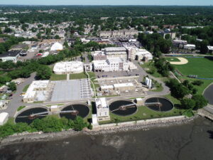
Through an existing On-Call agreement to provide GIS Consulting Services between GdB and Westchester County, GdB assisted the GIS team to perform a GIS Needs Assessment across multiple County departments. Westchester County has been collecting various forms of geospatial data from projects performed by County staff as well as contractors and consultants. A Needs Assessment was suggested to the County GIS team as a first step towards organizing and standardizing the Drone and LiDAR data so that the data can be used and leveraged throughout the County. The GdB team was uniquely positioned to complete this task with Westchester County given our Land Surveying, LiDAR/Drone, and GIS technology expertise.
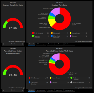
GdB has teamed with STARR II, as a survey subconsultant, through four fiscal years to perform Field Survey to obtain current “on the ground” data to support a RISK MAP Study in FEMA’s Region II which includes, Ontario, Orleans, Tompkins, Yates, Rensselaer, Saratoga, Seneca, Wayne, Chatauqua, Franklin, Genesee, Jefferson, St. Lawrence and Wyoming Counties.
This was GdB’s largest ground control effort for Aerial Imagery to date. Field Crews set aerial targets at specified distances and provided survey accurate coordinates for photogrammetrists to perform their work to accuracy standards. GdB prepared and provided a complete survey file in AutoCAD Civil 3D utilizing pipe networks and progress was constantly tracked in GIS. This huge survey and mapping effort was expedited and completed within only six months, on time and within budget.