Remote Sensing

Patrick Engle

PROJECT MANAGER

In early 2022, GdB Geospatial brought Geomaps International on to our team. Geomaps has specialized in aerial remote sensing services since 1987. Their experienced staff, combined with state of the art instruments and software, provides photogrammetric measurements and digital mapping for Civil Engineers, Land Surveyors and GIS applications. Over the past 32 years Geomaps has performed aerial mapping services for the Army Corps of Engineers, FEMA, USDA, government agencies and utilities companies. The photogrammetry staff transform information about the Earth’s surface into spatially accurate vector and raster files that are tailored to our clients needs. Cost effective innovations, high quality graphics and timely solutions are what set Geomaps apart from the competition. GdB has always recognized this, utilizing these services for many projects. Bringing Geomaps on to the GdB team allows us to provide these services in-house, passing effective project strategy and cost savings to our clients.

What is Remote Sensing?

Airborne Remote Sensing describes a suite of technologies that use overhead photography, sensors, and satellites to create detailed maps and measurements. There are two types of remote sensing technology: Passive Remote Sensing (or Photogrammetric remote sensing) - The collection of reflected light in the form of color or RGB (red/green/blue) pixels that form photographs. Active Remote Sensing - Emits energy that measures the time it takes for that energy to reflect, creating a 3-dimensional dot that is recorded as a node in a point cloud.

How did Photogrammetry/Remote Sensing originate?

Remote Sensing and Photogrammetry first started with the use of flights and balloons taking early images of the ground below. The remote sensing service that we know today started back during WWII evolving throughout the Korean and Vietnam War, for military planning and operations. The first Photogrammetrists started their careers out of the military, where they were trained to identify military assets and facilities through Remote Sensing. Individuals would draw out the contours of a site, trace with a pencil, draft in ink and/or scribe the contours of the location to make a map. Creating a map could take weeks to complete and was a very time-consuming and expensive process. Fast forward a few years and technology started to grow out of the military and into the private sector. Not all who worked in photogrammetry came from a military background, however.

How has technology played a role in Remote Sensing?

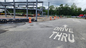
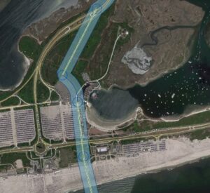
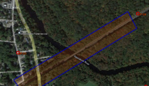
As we know, technology is always changing. So, do we use the same process for remote sensing now that we did over 50 years ago? Absolutely not! We’re using faster technologies, computer software, drones, and even piloted airplanes. What was once taking weeks to complete, can now be done in ~8 hours or less depending on the project site. The great thing about technology is that there is always something new, better, and faster around the corner. However, that doesn’t always mean that we have access to it. For example, drones are driving the future, but there are significant airspace restrictions. Did you know that you can’t operate a drone outside of line of sight? This is known as beyond visual line of sight (BVLOS) restriction. You can’t fly over people or moving cars, making the option to fly a drone a great choice for an underdeveloped plot of land, but not so much for an area with lots of people and traffic. For populated areas and everything in between, a site can be flown with a fixed wing airplane. A manned airplane with a pilot and a camera-man can be flown anywhere with less restrictions when compared to a drone for great photogrammetry results. Thousands of acres can be shot in a day by using a manned airplane.

Why is Remote Sensing such a great service option?

Remote Sensing can be used on any job site, really coming in handy with very large project sites. An area that could take a field crew multiple hours and days to complete a traditional survey can be flown in just a few hours. Not to mention, the cost of remote sensing is cheaper than traditional survey because of the processing and time savings.

FAQ

Leverage GdB's leaf-off stock imagery when your project can't wait.

How can we add value?

You Fly, We Map.

Nassau County DPW – Bay Park STP Ocean Outfall Effluent Diversion

GdB was hired as a subconsultant to provide a variety of Land Surveying services for this large scale effort by Nassau County DPW to divert dry weather effluent from the Bay Park STP to be discharged via the ocean outfall at the Cedar Creek WPCP. This required construction of a new dedicated pump station at Bay Park, a new force main between the two facilities and all related control systems and appurtenances required.

Read More »

PSEG LI – Article VII Malverne to East Garden City

GdB was hired by Burns & McDonnell as a WBE Certified Subconsultant to provide various Land Surveying services on a proposed route for a new 138KV Underground Transmission cable to be used by PSEG to deliver reliable service and grid resiliency to Southwest Nassau County after the failure of two existing 50+ year old cables.

Read More »

NYS Thruway Service Area Redesign

GdB field crews performed detailed topographic and utility surveys for each site, approximately 1.5 to 2 acres in size. All existing structures, pavement edges, sidewalks, curbing, ADA improvements, fences, gates, retaining walls, signage, lighting and visable surface hardware for utilities, and any other planimetric features were located.

Read More »

HVDC Poseidon Transmission Cable Project

This was GdB’s largest ground control effort for Aerial Imagery to date. Field Crews set aerial targets at specified distances and provided survey accurate coordinates for photogrammetrists to perform their work to accuracy standards. GdB prepared and provided a complete survey file in AutoCAD Civil 3D utilizing pipe networks and progress was constantly tracked in GIS. This huge survey and mapping effort was expedited and completed within only six months, on time and within budget.

Read More »

Amtrak Bridge Replacement over Pawcatuck River

For the site, GdB conducted due dilligence boundary research, obtaining records from publicly available municipal agencies and Amtrak. GdB field crews completed a Quality Level “C” utility survey, compiling record plan data with located surface hardware. This mapping was included in the basemapping deliverables to the client.

Read More »